It always amuses me when around the level of Inverness the road signs have the simple word "North" emblazoned on them. People from the south of England must wonder just how much of the country is actually left. It is a bit different up here: there are more roads on your typical Barratt's housing estate, probably more people as well. It's none the worse for that.
With bikepacking becoming more popular we had options for the first Bank Holiday of May of the Welsh Ride Thing, the Cairngorm Loop or something of our own. With the last weekend of May being the start of the HT550 one possible option was to recce part of the route which since I'd done very little of it (and much of that in the opposite direction to that used by the HT) might be useful. For once it looked like being further north might pay off as bad weather was forecast for the south. Rather than drive up in one go I took Friday afternoon off work and booked a rooom in Inverness for the Friday night.
The overall plan was to park near Rosehall and ride the loop over the next couple of days just taking things relatively steady with bivvies planned for Lone/Achfary and the bothy at Suileag near Suilven which would give two days' riding of 75Km and one of 30Km or thereabouts. This was touring and checking things out rather than racing, there'd be time for that later in the month!
All too soon we were ready to head off up Glen Cassley. This is quite a gentle introduction and you slowly gain height over the course of twenty kilometres or so. Just as the tarmac ended we came to a padlocked gate. They were obviously serious as it was doubly padlocked and had CCTV mounted on the post. Fortunately there was a way past though it did require a bit of bog hopping.
 |
| Heading up Glen Cassley with Ben More Assynt as backdrop |
The next couple of Km are on a gravel track which ends at a hydro electric facility. This must be operated remotely as machinery was in use but there were no vehicles or anyone about. The access road to the facility is lovely smooth tarmac. Unfortunately there's a 300m hill in the middle of it! A good climb though and an even better descent on the other side.
 |
| The descent off Moavally with the route to Gobernuisgach Lodge through the fold in the hills in the background |
The miles have passed quickly but we'll get slower as we head into the northern part of the Reay Forest estate to head round to Glen Golly and Bealach Horn. A couple of bikers ahead are moving very slowly, it turns out to be a mother and daughter and the latter's bike needs a bit of TLC as the rear mech is in an odd position. An exploratory push and the mech springs back to its normal position: a stone probably hit it and it had flipped upside down.
 |
| Heading to Gobernuisgach with Ben Hope in the background |
Before too long we are rattling down to the remote (and unpronounceable) Gobernuisgach Lodge and the start of the climb up Glen Golly. Initially a good quality quad bike track it begins to deteriorate with a series of very steep and loose hairpin bends on the edge of a deep gorge that lead to a hidden meadow. We stop here to have something to eat trying to find somewhere out of the strengthening wind. The track continues in a mixture of rideable and steep loose unrideable terrain, ahead loom the zig-zags on Creag Dubh. These are definite push terrain though once on top it's a broad plateau with most of the climbing done for a while.
 |
| Approaching Creag Dubh |
 |
| At the top of the zig-zags |
Whereas some estates keep their tracks in good condition, Ben Alder being a good example, other have for whatever reason let them decay. This could be for a number of reasons, economic, change in use or technology snowcat instead of pony. Unfortunately the path past Lochan Sgeireach is one of the latter. In places it is rideable but then big holes block the way and you have to man-handle the bike across them. Even where the surface is apparently good and solid stone/gravel it feels soft under your wheels though I suspect this is due to the loosening effect of winter frosts.
 |
| Some parts are rideable. |
 |
| Some aren't! |
The descent into the valley of the Allt an Easain Ghil is steep and the path is in very poor condition and hard to follow. Originally it must have crossed open ground but erosion has caused the surface peat to slip down the hillside in a series of huge slabs. The result is a few tens of metres of path then a drop of a couple of metres down a wall of peat before trying to find the path again. Finally we reach the burn, time for wet feet.
 |
| Climbing up to Bealach Horn. An Dubh Loch behind. |
The climb out the other side is on a track but this also seems as if it's falling into disuse as large sections are covered in moss and lichen. For a kilometre it's a push until the angle finally relents and it's possible to ride the remainder to the bealach. There's snow patches, winter still has a tenuous hold on the ground here. A rainbow highlights Cath as she gains the top. Just the descent to Lone then we'll bivy.
 |
| Approaching the bealach |
 |
| Starting the descent to Lone |
About a kilometre down the descent Cath gets blown off her bike, fortunately no damage done, it shows how strong the wind is getting. We take our time picking our way down the occasionally steep and loose track until a series of zig-zags leads into the trees and then through the large split boulder. We find a reasonably sheltered spot in the trees and set up the tarp and get a brew on.
 |
| Our hotel for the night. |
 |
| The famous split boulder. Pure luck it didn't block the track! |
The following morning it's still windy. Amazingly there's no dew on the tarp so packing is easy and we are away by 0730. The day starts with the biggest climb, up out of Achfary. Quite a lot is rideable but some bits it's just easier to push. On the plateau there's a howling wind but there's an old shieling to shelter in while I wait for Cath. The track is in good condition and it's a blast down the other side all the way to the coast. Time for a second breakfast at the hotel in Kylesku.
 |
| Approaching Kylesku |
 |
| Just one of many hills on the way to Drumbeg |
The next section is all road but it's not easy as it's one of the bumpiest roads in the country. Fortunately the wind is now mostly on our backs, at one point I'm trackstanding to allow a car to pass and the wind is blowing me uphill. Another stop is in order at Drumbeg stores. "A lot easier now to Lochinver" says the owner. She's mostly right, it's just that about halfway along the coast we turn into the wind and things get a lot harder.
We are trying to get to the pie shop in Lochinver before it shuts for the day so decide to avoid the route through Achmelvich and keep to the road. I doubt it was any easier. It was only made worse by the fact that the shop was shut all day. In fact all the village seemed shut apart from a couple of bars. A soup and a toastie each and we make our way onwards.
 |
| Heading to Suileag bothy with Canisp as backdrop. |
The trail to Ledmore has been described as being 95% rideable to where the Suilven path leaves it and 95% unrideable after that. We are stopping at Suileag bothy so mostly rideable for the remainder of today. There's no rush since we've got five hours to do about 3Km. There's a walker in the bothy waiting for his mates who've headed up Suilven. We won't be alone tonight.
We've eaten by the time they arrive back, they turned back before reaching the summit due to the winds. We're in bed by 2100 as we plan to get up early in the morning.
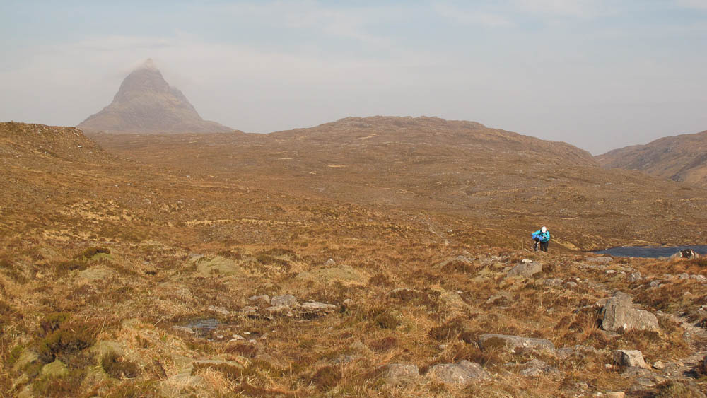
The morning is no less windy. We have been this way before: ten years ago we looked at riding through to Ledmore but about a kilometre after the bothy we turned round and took the track to the north which was rough and mostly unrideable. True to reports the quality of the track soon deteriorates and we are reduced to pushing with the very occasional bit of riding. The views though are fantastic with Suilven wearing a cloud cap.
 |
| Those clouds aren't static! Suilven looking moody. |
The hours pass and we seem no nearer the road at the far end. The track looks as if it should be rideable but every time I try to ride I only manage a few tens of metres before the ground becomes too rough again. It's well into type two fun territory and a long descent to the final loch and finally there's a track that is mostly rideable. One last rise and the gate is in sight. It's road from here back to the car.
 |
| A few bits are rideable |
 |
| But mostly it's pushing. |
 |
| Not far to the road from here |
The bad news is that it's into the wind. Even the downhills need pedalling. An executive decision to stop at the Oykel Bridge hotel for something to eat before the drop down to Rosehall. The last bit of road is enlivened by a deer rushing across the road between Cath and myself, fortunately missing us both. Back at Rosehall I hear my first cuckoo of the year. Time for the long drive home.


No comments:
Post a Comment