Monday, 16 May 2016

Jenn Ride

Cancer touches many people.

Last year the husband of one of my cousins died from cancer, eighteen months earlier another of my cousins died from pancreatic cancer, his father had also died of lung cancer some thirty years before that. Nearly thirty years ago my mother died of cancer. Cancer touches many people.

Jenn Hill wasn't someone I personally knew but her death last year at a distressingly young age affected many in the UK mountain biking scene. There have been several fundraising "events" for Manorlands Hospice who cared for her, as they have done for many others, in her last days. The latest of these, a 150Km ITT, took place last weekend in the Lake District.

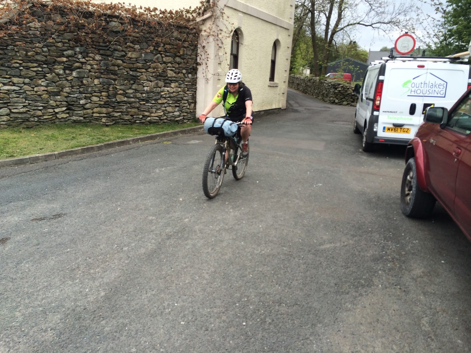
We hadn't considered entering the group start primarily since it had filled up very quickly. As is often the case with online registration there were a few who then decided that it wasn't for them or had other commitments so there were some places available, a donation via justgiving and the organiser, Rich Munro, gave us the nod.

A look at the route showed a convoluted line that didn't stray too far from the start/finish point in Staveley but managed to include just about all the quality riding in the South Lakes. There was about 50Km that I hadn't ridden before. I wasn't thinking about racing the route so enabling distance markers on the web display showed some likely bivvy spots at about the right distance for a day's steady riding. With the route passing through or close to many villages there would also be plenty of opportunities for cafe stops and a pub meal!

The weather was set to be fine (after at least a week of fine weather) though slightly cooler than of late and with chilly nights down to about 6C. I reckoned I'd be warm enough with just the quilt and a decent sleeping pad inside a bivy bag.

An early start got us to Staveley in good time. Park up, have some breakfast at the cafe, get the bikes ready. Near the allotted start time the organiser Rich gave a quick briefing - "there'll be lots of tourists after Ambleside" and Jenn's husband Tom said a few words. Then we were off.

The first Kilometre or so was a rolling start, a depart fictif if you like, before the first hill hove in to view and the fast guys were unleashed. No need to rush for me, I only needed to average 10kph to make it to my intended bivy spot accounting for a couple of cafe/pub stops. Chill, have a chat with other riders, take some photographs. In the event it didn't turn out quite like that.

It's a selfie!

Once the initial jostling for position on the first section over to Longsleddale is done, the riders start to string out with increasing gaps. Sometimes you are with riders, other times you are on your own, sometimes the elastic snaps and you fall behind, sometimes you snap the elastic.

Heading up Garburn Pass I hear my first cuckoo of the year. As I descend I'm enjoying it that much that I miss the turning for Dubbs Tarn - by the time I realise I'm actually on the return part of that loop. After a bit of umming and arring (well swearing actually) I decide to just carry on. It turns out that there are quite a few riders who end up being "economical with the route".

On the way to Jenkin's Crag with a fine view over Windermere


A stop to refuel in Ambleside at the filling station, a couple of minutes later I come across a large group stocking up at the Co-op so a bit of a chat then out towards Rydal. Heading round Loughrigg a couple of riders catch me up and we ride together until the steep climb on the south side of Loughrigg. One of the riders is riding straight through and I realise that his pace is much too quick for my strategy so I let him go and wait for the other rider.

"Bike behind!", the woman steps to the side and as I approach she makes another step, slips on some dead bracken and screams. We stop and check how she is. A couple of fell runners who were nearby come down to assist. After a while we try to get her to stand but she is in no state to move. Time to call out Mountain Rescue. After a bit of technical wizardry our position is determined and they are on their way. By the time they've arrived and dealt with her and got ready to carry her down an hour and a half has passed. http://www.lamrt.org.uk/incidents/2016/incident/44

Heading up Langdale towards the New Dungeon Gill, I pass a couple on road bikes who obviously take umbrage at a fully laden mountain bike overtaking them as I'm aware of them drafting behind. I slow up as I meet another rider and after taking on water at the Stickle Barn we begin the "interesting" track over to the Old Dungeon Gill. This is a mixture of hike-a-bike, riding and occasional boulders to hop around. The other rider is on a singlespeed so once we are back on the road the elastic snaps and he falls behind.

There's a lot of the next section that I've never ridden before, some of it's a push, some is rideable, the woods are full of bluebells and flowering wild garlic. I join another rider just before High Tilberthwaite and we ride together as far as Hawkshead via an extra unscheduled loop to get to Hodge Close, ah well. I had intended to eat in Sawry but with the MRT delay Hawkshead seems a better bet. The first pub we come to has rather a large number of bikes stashed outside - seems like a lot of other people have the same idea.

"Forty minutes wait for food love. We are a bit busy." It will have to do. Some riders leave, some more arrive. Tales from the trail. Non-riders looking puzzled at the variety of tyres on show. The food arrives in twenty. Needing water bottles filling I nip back to the bar and they are still "busy" so it's off to the Co-op and grab some there. It's only when I've begun to pour it into my bottle that I realise it's sparkling water - euchh!

I get lost in the ginnels trying to head up in to Grizedale Forest until a resident (kindly) puts me right. I get lost again in the forest and miss out the second part of the North Face trail but have quiet fire roads instead. As I head out of the woods towards Parkamoor the sun is ready to set. It's always stunning up here and this evening is no exception, I stop to take some shots.

Early evening on Parkamoor overlooking Coniston Water

The normally wet track back into the forest only has a couple of deep pools then it's a long technical descent to Seathwaite and a stiff climb back out. The bridleway on the other side is blocked due to forestry work so there's a detour down a footpath which suddenly gets very technical and steep so there's a bit of walking downhill. Another climb and descent and I'm out of the forest before dark.

Riding along the shore of Windermere there's only dog walkers for company. One last climb in the arboreal gloom to get on Claife Heights and it's properly dark by the time I call a halt - I've been riding by natural light up to now not bothering with my light. We've only one proper one person tarp between us so Cath's using that and I've a Tyvek sheet that I can use as a tarp - it's actually its first outing. I've just set it up when two riders pass by. One stops and asks if he can take shots of my bivy (!?), he's doing an article for the magazine that Jenn worked for. I hope that my efforts don't cause too much merriment.

My hi-tech bivvy!

It's a cold night, close to freezing and a few degrees cooler than my quilt is rated to. I spend the night half asleep getting woken at intervals by the geese on the tarn, really noisy and loud birds. It's starting to get light so up and make a brew. Nearby is another rider bivvying out, it happens to be the same guy who I was with on Loughrigg. The brew's just come to the boil when I knock the whole thing over! Sod it! I pack and get on my way.

An early morning vista. Somewhere in there are some very noisy geese.

One thing about being up and about very early is that there's lots of wildlife around that hides away once "normal" human life takes place. I see deer and small mammals taking advantage of the small amount of daylight that we permit them. Windermere has an autumnal mist hanging over it slowly burning away as the sun's power increases.

Breakfast courtesy of Ambleside Co-op then it's on to the climb up Jenkin's Crag and back down to Troutbeck. I get lost in Limefitt Park trying to find my way out of the maze of caravans. Steady riding now, round by High Borrans then on to Kentmere Park and a blast down to Kentmere Hall. Just one climb to go.

Not sure of how many of my five a day are in this lot!

Halfway up this I catch up with the lad on the singlespeed again - he had originally thought about riding through but had bivvied a little further on than I had. We ride together to the end.

Final time of 25hrs11mins but that's not the point.

Over the next few hours more groups of riders arrive but where was Cath? There are various reports of her, some from the previous afternoon but the last reported sighting was in Ambleside: "She'll be about an hour behind us, she's going well.". I'm just starting to get worried about her when she appears out of the final ginnel looking rather tired, she'd had a blue air moment on the last climb. She'd bivvied near Parkamoor so had three or four hours extra riding to do compared to me.

Cath about to finish.


Here's a short video.

Monday, 28 March 2016

Braunton 150

Pink! PINK??! Which idiot's idea was it to make the default nighttime route marker on a GPS pink? And it's only half the width of that used in the daytime. I'm stood at the bottom of a very steep hill. I know it's steep because I've just ridden down it. I now know that the bridleway I should be on is at the top of the steep hill. It's coloured PINK! My "reward" having pushed to the top of the hill is a lovely piece of flowing singletrack along the top edge of the woods. Things were going to get worse. (This paragraph originally had a lot more words!)

Pre ride at the Wild Thyme cafe


Friday had started well. Get into a rhythm, don't push too hard and see how far I'd get. I rode with another rider for a while until I gained distance on a hill so carried on. On a part push, part ride section (cattle and horses really do cut up soft ground) three of us grouped up and we rode together for most of the rest of the day. The bridleways leading to and from Simonsbath alongside the River Barle are ace in the sunshine. As evening approaches, one drops back to put on more clothing while myself and the other push on past Tarr Steps and over to Winsford. The light is fading quickly as we pull out on to the moorland of Dunkery Beacon. The other rider has pulled away now and I'm on my own. I'm struggling to see the PINK line of the route but I've been here before so have a vague idea where I'm heading. I spot the tail light of the other rider ahead so have a clue as to where to go.

One of the early lanes

There's a bog ahead, not just your ordinary bog but one a leprechaun would be proud to have as a moat around his home. Even in the gloom it's luminous green. Fortunately there's a fence where I can practice my Indiana Jones bog crossing technique. Using the bottom wire of the fence for footholds and the top for my hand I edge across, the bike partly supporting me as well. My hand tingles, trapped/damaged nerves from the constant battering, then ZAP! It's an electrified fence!

Climbing up from Cornham Ford


The descent off the Beacon goes on for a long time, initially a stony track to a road crossing then a loose, rocky bridleway that seems never ending and it's taking a lot of concentration. The pub in the next village turns out to be a very posh country hotel - I don't think they'd be too impressed with a mucky mountain biker turning up. Minehead it is then. Except I get lost in the forestry between me and there. I'm trying to make sense of the map on the GPS when the battery dies. Great! Then I hear traffic - just round the corner is the main road.


Somewhere in the middle of Minehead I bump into a familiar face outside a convenience store that has everything you'd never need, by the time I've raided the shelves the third member of our disparate group has arrived. My plan now is to find somewhere to bivy. The other two press on ahead on the climb out of town. On the hillside I come across a potential site but the wind seems to change so knowing there's a tricky descent I carry on. Eventually I find a suitable site by a community hall. No need for the tarp there's plenty of shelter should it start raining.

A community bivy spot


Left down the rocky track or right up the rocky track? It's going to go up isn't it? A few minutes of pushing then a bit of riding through the farm yard then eventually the track steepens and I get off and push again. When the gradient does ease off I am now facing in to the first part of the forecast storm and it's all I can do to keep walking and pushing the bike forward across soggy fields. I'm not happy and am thinking of quitting. Eventually I reach a road, turn and have the wind on my back. The GPS indicates a right turn and through the mirk I see a track skirting the hillside. But it isn't that, instead it's a sublime piece of rocky singletrack dropping in to the coombe and out of the wind. It twists in and around trees teetering, balancing above the beck until I reach a gate. There's a climb before another great piece of sandy singletrack.

Riding by the River Barle

The problem with following a course on a GPS screen is that you could be anywhere. Yes, you know that the marker on the screen is you but, where is it? Where are you? It could be Devon, it could be Somerset, it could be Cornwall. No, not Cornwall, things aren't that weird. Yet. People in cafes ask me where I've come from: "Bollock?" I reply uncertainly, "then round by Badgerwank Water and down to Lynn Foulds Wood. I don't know! It was PINK!"

"Unsuitable for Motors", I'm pushing up a stupidly steep road, the surface ravaged by previous storms, as I get higher the road appears to be moving - it's water from the surrounding fields taking the easy route to the sea and it's pink. At the top of the hill I'm once again facing the teeth of the gale, it's all I can do to keep pushing the bike, with the cramps I can't ride so I'm unable to generate enough warmth to fend off both wind and rain. I'm done. I make the decision to stop at the next pub or cafe and quit. Of course the next pub is at the bottom of the hill I'm now at the top of so I get even colder reaching it. They've stopped serving food so I'm reduced to cups of coffee and hugging a teapot of hot water.

Despite quitting and having done 200 out of the 240Km (I was that near the end)  I have to say that there's some great riding, some tough climbs and great views.

Cath arrives to pick me up and we head in to Ilfracombe and food: pink crab!

Monday, 11 January 2016

Bach to Bach

I'm starting to worry. It's 9pm in January in rural Mid-Wales, there's not a house light to be seen and I've been in driving rain or sleet for hours now, my light has decided to go in to emergency mode and I've no idea how much longer the battery will last and no opportunity of shelter has presented itself. 

A vaguely flat spot by the side of the forest trail will have to do, I break out the tarp. A few minutes later the shelter is up and the wind changes and blows straight in. Things aren't looking good. Head down, I look round. Nothing but steep slopes with sparse vegetation buffeted by the wind. I wander down the track and round the corner I pick out a shape. It's a calf creep feeder, I look inside and the floor is dry. Result! Back to the bike and get everything together again and return to the creep feed. Draping the tarp at the windward side and end I manage to get things windproof. Sleeping mat and bag unpacked, time to get in to dry clothes and make a brew.

I'm halfway through the Bearbones winter event, this year entitled "Bach to Bach" as the points of interest all contained that Welsh word (it means "little"). I had ideas of visiting all the fourteen grid references that had been sent to us and had worked out a 190Km route that linked them all up with as little hike-a-bike as possible. There's no requirement to visit all the points, it's up to the individual as to which and how many they visit, but I like a challenge and it would be a good assessment of my fitness.

It didn't quite work out like that.

All this area is new to me which has advantages and disadvantages, the latter would become quite apparent. In a few minutes I catch another rider and we ride together for a couple of kilometres until I head east to pick up a checkpoint that he has no interest in. I didn't know it at the time but he would be the only one out of nearly seventy who had turned up for the event that I would see away from the event centre.

Off-road the effect of the winter's incessant rain was soon apparent, uphill was basically a push as there was no traction unless you were on a stone track, downhill was an exercise in care/frustration, any attempt to turn at speed was really about controlling the slide. Somewhere admist the slipping, sliding, spinning, pushing I was looking down in to the remote Hyddgen valley. It was around here that the rain started. The ford by the farm steading could be avoided by a bridge that had seen better days though the river might just have been manageable. The next river most certainly was not. A footbridge further upstream provided temporary salvation, an attempt at crossing a side stream saw me in thigh deep water, if I wasn't wet before I was now.

The track became road and I picked up speed again until I came to a junction: left or right? A thrubbing of knobbly wheels announced the arrival of a solitary mountain biker who just happened to know where he was. A chat and some directions and we went our separate ways. He was the only person I spoke to or even saw between leaving the rider near the start and Rhayader. I missed the turning for the shortcut so ended up hitting the main road at the bottom of a long, long hill. This wouldn't have been so bad but the wind and rain had picked up so I had to pedal down the other side as well. The two grid refs on the ridge between the road and the Elan Valley would have to wait, I was getting cold. So cold I couldn't even undo the buckle on my helmet or turn on my rear light. Some serious manning up later and I was on my way again.

The pub in Rhayader was already serving food but my first request was for a cup of coffee, not so much to drink as to warm my hands by. I was putting out more heat than the fire in the corner so it took a long while to warm up. The cold had also affected my stomach and it was hard work eating. When I said I was heading out again to carry on riding I got some very strange looks, not sure if they were of astonishment or pity.

My optimised "all points route" had missed Rhayader by a valley to the north, now the way lay up a long road hill. Fortunately the wind was on my back. The road turned to track then entered more woods. Somewhere I missed the exit for the other side and emerged in the wrong place though I didn't know it (I had to check my Strava trace to find where I'd been). The next grid ref should have been left then almost immediately turn right so I turned left except there was nowhere to turn right. I carried on, a farm building offered the prospect of some shelter for the night but on inspection there was no room at that inn. The village I should have entered a while ago loomed out of the dark, at least I knew where I was now but sod the grid ref. There were woods ahead and hopefully shelter, I was in need of it. The creep feed beckoned.

Your room sir!


The morning light was grey again, putting on wet cycling trousers isn't pleasant. My seat pack is now full of yesterdays soaking cycling kit and weighs about double what it did before. The next grid ref is further along the track but not before another section of pushing across a grass field. There's a couple of tyre tracks here so someone has been here before me. The bright lights of Llanidloes beckon but I'm too early for the Co-op so a quick out and back to visit another grid ref. Pre-tax sugar drink and a Mars Bar are my reward before it's uphill again to the next grid ref. I can't find the start of the bridleway to cut across to the next road so it's back down the hill and up again. Easiest now to stick on this road to the next village then up the valley. Not as aesthetic but who cares.

The last hill, just one chevron on the map presumably because they couldn't fit in the three it deserves, even after leaving the road and the angle eases I'm still pushing as it's simply more energy efficient than trying to pedal up what used to be grass meadow. I reach the forestry edge and there's no let up as clearance work has created a minefield of brushwood and swamp. Finally I see the windfarm that marks the start of rideable ground again and clearing the woodland I pick up the access track, one short rise then it's down hill, track giving way to tarmac, open fell to hedges, cars. All that's left is the main road back to the start.

The scores on the doors were: 155Km ridden; 3300 metres of ascent; 8 grid refs visited; 2 sets cycling kit soaked.

Day one


Day Two:


Thanks to Stu and Dee for the organisation, tea and cakes.

Monday, 5 October 2015

A little exploration does you good.

Sometimes it's worth doing a little exploring, while things may be known to others it's nice to be able to find them for yourself rather than having them handed to you on a plate. With Cath off doing the Yorkshire Dales 200 I'd got the time to myself to locate a couple of descents in Swaledale that I knew about and knew of their approximate location but had never been to or ridden.

The first began near the road and I'd remarked to Cath several times that "That gully starts round here", so parking up near where I thought it would be I followed the first path through the heather that I came across and purely by chance got the right line! A piece of singletrack snaked its way along and down an old "hush", a very old (back to Roman times) means of mining, until it opened out in to a set of mine workings. All very rideable so I walked back up to the car.

The second trail is known as the "Pipeline Descent", I've seen it in a couple of videos and had read a blog on how to get to it, though the latter didn't make a whole lot of sense plus it was described from the opposite direction to how I was intending to get there.

Setting off from the Dales Bike Centre, it was the usual ride along the banks of the Swale until it was time to gird the loins and head up on to Harkerside Moor. I must still be suffering from the cold of a couple of weeks ago and felt like I was struggling and my legs just weren't working. Ahead on the upper traversing track was a group of riders, probably watching me heave my way upwards though they'd gone by the time I reached their position. As I got on to the plateau I could see them contouring the edge of the moor - exactly where I needed to be heading! They must be aiming for the same descent. With the morning dew still on the grass it was quite easy to follow them threading my way through heather and patches of open ground.

The group were just beginning their descent when I got to the start. Declining the offer of the last two to go ahead as I was sure I'd be slower than them (I'm always really slow on descents) I watched them on the first part. The ground wasn't steep but there was really just the one line through it - a semi traverse before pointing downhill as the angle eased and a blast through more heather to the start of the next drop. I committed my usual sin of going too slowly and had to dab but there was really only one short section that was hard. The next part of the descent was in a shallow gully so no chance off falling off and rolling down the hillside, you just had to keep rolling downwards. There was a slot in the bed of the gully about twice the width of the bike tyre so it was a matter of ensuring you followed that. Halfway down there's a couple of blocks across the line so you need to keep some speed going. After that it's just more heading downwards to the moorland below.

I caught the group up a little later, they were on an Orange Bikes demo day and Stu the owner of Dales Bike Centre was with them showing them some trails. After a chat (and to get my breath back) I headed up and across the moor to find the other gully descent. A bit of road climbing and I was there.

No stopping and I was straight in to it, nowhere technical, the hardest part was making sure you had your pedals set correctly so you didn't catch any of the rocks to the side. The whole thing was over far too quickly but then in the workings below I got the wrong side of a drainage channel so a quick dismount and a hop over it and I was on my way again. The rest of the ride was a simple blast down old mining tracks and the road back to the Centre.

After some grub I declined to head out on the second demo ride and drove up the dale to Muker. One published ride that I'd not done in Swaledale was the ride over Kisdon, a curious hill that divides the upper dale - the river runs to one side, the road and habitation are on the other "dry" side. The only problem was that I wasn't entirely sure how to get across the river to begin the loop.

In the end I simply road back down the road until I came to the bridge that we'd crossed on the YD300 and grunted and groaned my way up the tarmac climb on the other side. Eventually the tarmac gave way to rough farm track and I was following the Swale in a wonderful semi-abandoned part of the dale.

All too soon the track began to head upwards towards the wonderfully named Crackpot Hall then it was back down to the level of the Swale where a three-way fingerpost sign gave no indication of where to go (I'd no map with me hence the earlier uncertainty on how to cross the river), two fingers simply said "Pennine Way" and the third, pointing back the way I'd come: "Bridleway". I took a punt and headed down to the bridge and pushed up the other side until another sign indicated "BW Keld". All that remained was the climb back over Kisdon to Muker.

This started off OK but after about 100 metres my legs and lungs simply gave up so it was a case of pushing the bike to the top of the steep section and the first gate. The rest of the climb was steady and soon loose stone gave way to grass, the general angle easing all the while. A couple more gates and I'm at the top. There's hardly any time to savour the views as the track drops away  quckly and begins a helter-skelter of a descent down to Muker pausing only for several gates and losing 250 metres of height in about 1.5 kilometres. Not a route I'd like to do in the opposite direction! A gentle roll back to the car and I'm done.


Somewhat curiously despite my feeling that I wasn't up to par, Strava shows that I recorded some of my best times on the rides including some top ten times.

Sunday, 6 September 2015

I see Thin People

Sometimes it's good to do something new, it shocks the body and mind and gets you out of a rut. So it was that I decided to enter the Kielder 101. That's kilometres not miles. It's a mountain bike race in and around Kielder forest with the "unique feature" of heading over to Scotland for part of the route.

Registration is on the Friday night so after that and something to eat I turn in for the night, kipping in the car - the campsite was full though apparently they were letting people pitch up without having booked.

I wake at 0400 with the arrival of more cars and having failed to get back to sleep get up at 0600 and make a brew and have breakfast. More people arrive and bikes are removed from cars and assembled and tested. The start is at 0730 with a final briefing at 0715.

Like a pro road race, the start is neutralised behind a vehicle for the first couple of kilometres then we turn off the Forest Drive and it's every man and woman for themselves. The first mile or so is uphill so everyone gets strung out before the first bits of singletrack.

The nature of all open races like this (fell races are similar in that you can be on the start line between the national champion and someone who is in their first race) is that you pretty soon get in to a group of riders that you pass, get overtaken, pass again. So, at least as far as the first border crossing I'd keep seeing the same people.

Apart from the first couple of kilometres and two road crossings the entire route is off-road, a mixture of fire road, single track and event specific sections that cut through virgin terrain. The first of these was a "short cut" between two fire roads and  mainly consisted of picking your way through moss covered tree roots.

The second food stop was at Newcastleton in Scotland, one of the options was being able to pack a bag with your own food and have it ready for you there, so savoury food rather than sweet was in order plus a restocking of my on-board supply then it was off again.

The rider I was with at this point would pull ahead for a while then stop and try and stretch his back - "Pilates on the bike is hard work!" Eventually on a climb I think he stopped for longer and I didn't see him again.

By now everyone was well spread out and between the second and third feed stations, 30Km in distance I saw only six riders - two passed me and I passed four more. I didn't stop at the third feed station just got my timer clocked, I'm well inside the cutoff, and then on my way. A long drag uphill then bits of singletrack descent to the road. Just one uphill to do.

Marked on the map as "Scorpion, the sting in the tale" it seemed to drag forever, just when you thought you were heading downhill you'd be taken in the opposite direction and yet more climbing. Eventually there's basically no more up and it's a case of sweeping down the singletrack descent. At one point there's a marshal who notes the two technical options ahead. I get off and walk, "Good choice!" says a voice behind. A rider catches up with me but declines to pass. The last technical section is down two sets of steps then a roll in to the finish and a "well done" and a handshake.

My official time is 6hrs47, I'd been aiming for 7hrs so am pleased with that.

No photos or video but here's the Strava trace.

Thursday, 3 September 2015

The Sandstone Way

"What is it?"

"I don't know, it wasn't there yesterday"

"Where's it come from?"

"Dunno"

"What's that?" said the third.

"Dunno".

"Does it move?"

"Not seen anything."

"Ooh, that's new." Said the fourth "What is it?"

"We don't know"

I roll over. There's a line of cows looking over the fence at us lying under our tarp.

With fine weather forecast for the bank holiday (now where have I heard that before?) on Friday night Cath came up with the suggestion of doing The Sandstone Way up in Northumberland. A slight problem in that she was heading down to her sister's for the night and would be back mid-morning so we (by which I mean I) had to get things sorted that night.

The general plan was to drive to Berwick, leave the car there and get the train down to Hexham, ride the route back to Berwick and drive home. The winds were forecast as strong south westerlies so we'd be going with the wind on our backs. All the descriptions of the route are for a north to south direction, this meant I had to reverse the downloaded GPX files (what I didn't realise at the time was that the route is slightly different depending on the direction you travel). I also ordered the route map from Amazon and hoped that the one day delivery would get to us in time (it didn't). The final problem was booking the bikes on the train, even now you can't book a bike reservation online to go with your ticket.

Fortunately on Saturday morning five minutes at Skipton station procured both seats and bike reservations, phew! Now we just had to get to Berwick in time to catch the train. The roads were generally clear, unusual for a bank holiday, and we arrived with plenty of time to spare. With the bikes kitted out we were ready to go. This particular train had a guards van with bike racks, unfortunately it was at one end of the train and our seats were at the other so a long walk through first class was in order - at least it was before we had started the ride! A change at Newcastle then we were crammed on to a two coach Sprinter train which became even fuller after the first stop at the Metro Centre and half of Primark's stock got on board. It was a relief to get off at Hexham.

Now we just had to find the start of the ride, I had partly remembered it began by the golf course near the river so we headed there and just began riding alongside the river. Eventually the GPS indicated we were on route. The rest of the evening consisted of riding along, realising (from a frantically buzzing GPS) that we were off-route, back-tracking and carrying on. The route is well signed for going N-S but not so much going S-N and not having a map didn't help matters.

We were on the lookout for these.

We had no bike lights with us as we weren't planning on doing any night riding and the sun was starting to set, in such circumstances you are very much dictated to by nature so time to stop. Ahead was a drop to a river which looked like it was sheltered but had the potential to be very midgey so we decided to stop out in the open The tarp went up quickly and just as quickly the wind dropped and we got mugged by the flying death. Eventually the breeze returned and we ate our tea and had a few sips of whiskey. By 2100 we had turned in for the night.

Our first bivouac.


In the morning we were up and away by 0630 having used the last of our gas making a brew. Not many people are up at that time and we try not to wake the occupants of the first farms we passed. A couple of ups and downs and we roll in to Bellingham which is one quarter of the ride. The Co-op was open so we grabbed some breakfast before pressing on.

The next section was frustrating as it wasn't obvious and was also hard work - it is new trail to link up existing bridleways and as such isn't yet marked on the ground, there'd be occasional tyre marks to show we were on the right (non) track but it was mostly guesswork. We eventually reached a good track and the next few miles went easily enough until we once again went wrong. Another trudge through rushes and long grass to find a hidden gate and we'd be back on track. A good bit of singletrack across a moor and we were spat out on to a road, this led in a remarkably straight line to the start of a long forestry section.

Now forest tracks are forest tracks and there's only so much you can take. After a point of indecision we took the wrong track which actually turned out to be the right track as we had a fantastic descent through bright purple heather to the Coquet valley. Some more bad route choices (we should have just followed the road) got us to Rothbury where we had a big meal in a cafe and managed to buy a map.

Among the heather above Rothbury.

The climb out of Rothbury is technical and would be a great descent (probably the only good one going south) but as a climb it was easier to push. What it did do was get you on to an easy but brilliant track contouring round the edge of the moorland through more irridescant purple heather. All too soon and we are descending back in to the valley. We've decided not to head out to Alwinton but use one of the shortcuts to get further north before nightfall.

In the event we miss the turning for the next bit of bridleway so have more road work to rejoin the route. We decide on bivvying at the next available site but in an arable valley this is harder than you might imagine. Eventually we find a spot and settle down, along with the cows.

A well deserved crab sandwich.


Another early start the following morning and we make good progress getting over the last major hill and down to the coast for a not too late breakfast. All that is left is an amble along the coastline back to Berwick. Unsure as to where the route actually ends we ride around in circles for a bit before deciding that the signpost with a sticker on is it. We're done!

Wednesday, 19 August 2015

A Dales Mini-adventure

Individual Time Trials (ITTs) are long distance mountain bike rides that as their name suggests are meant to be ridden as an individual. They aren't a race in the same way that a road biking sportive isn't a race but that doesn't stop people comparing times. The individual aspect can also be misleading in that if the course is well known then it may have a mass start and in this case you will likely find yourself riding with other riders at some point. The individual aspect really refers to self-reliance.

One point about ITTs is that they are usually at least 160Km (100 miles) in length which is quite a commitment for many people to step up to. Some of the publicised routes are linear which introduces the problem of getting back to your starting point though many do finish at or near railway stations. With this in mind I thought of doing a 100Km loop in the Dales as a sort of stepping stone to the longer distance.

A bit of studying of the map and we came up with a route that fitted the criteria and apart from a few kilometres at the start and finish had surprisingly little riding on the road to link things up once we got in to the meat of the riding. It even include some bridleways that one or the other of us hadn't done before. The general plan was to do about 60Km on the Saturday, bivvy out and ride the remainder on the Sunday morning. Even better it was a fine forecast for the weekend.

After a steady spin along the road to Buckden it was the first climb of the day up the bridleway to Cray. I'd done this on the YD300 and had to walk quite a bit of it so was pleased to almost clean it. Once up on Stake Moss it was a case of heading along just making sure that we didn't miss the turn for the bridleway down to Thoralby. Up here you can't see the nearby dales so it feels like you are on a huge plateau extending to the horizon, quite spooky really. The intial part of the bridleway to Thoralby is lovely grassy riding but the second part has been "upgraded" by the estate and is now a loose vehicle track, not very pleasant at all.

A choice of ways just before Thoralby so we head uphill and find ourselves navigating blind as we try to find "Folly Lane", in retrospect it might have been better heading the other way! By the time we crossed the river at Aysgarth Falls we were getting hungry so headed to the cafe - this is one aspect of ITTs that might seem slightly strange - you may use any facility along the route providing it is open to anyone. Suitably fed it was on to Carperby and a climb up on to the terrace above the valley floor. We've done this route along the terrace a few times, the YD300 does it in the opposite direction, so no navigation problems.

There was now the obvious problem ahead of the climb up the Roman Road. It's not steep but it is nearly eight kilometres of uphill on rough track. Being a Roman road it is also strikingly straight so there is always the way ahead in sight. Once at the top though, there was little more climbing left to do before the night's stop. Actually with a slight change of plan it was pretty much all descent. While on the short road section at the top of the road climb up Fleet Moss a group of road cyclists went past and I suddenly realised that I knew them - a bit of shouting and they came back for a chat.

The Roman road continues down to Ribblehead and is a cracking high level ride, the area to the SE towards Penyghent is barren and feels very isolated. Cut left and we follow the Pennine Bridleway down to Ling Gill our intended stopping point for the night.


Bivouacs are a continuous reassessment of what you've done before and adaptation to the current situation. You'll never get everything absolutely right: you'll have brought too much gear; not enough gear; the wrong gear; etc. There was quite a breeze where we planned to set up so found somewhere more sheltered - big mistake! As the sun went down it became midge hell. Our previous use of the tarp had been either as a classic tent like ridge or A-frame or as a lean to against a wall. With a clear night forecast we set it up as a half pyramid to keep any wind off us but be fairly open to allow us to get the "out in the air" feeling.

Another reason to head out on shorter routes is that you can test out strategies without feeling pressure from the event or distance. Food is one such item or strategy. There's a balancing act between carrying too much and tiring yourself out from the extra effort and not taking enough that you can't refuel. There's also the option between cooking food and eating it cold. The former requires that you carry stove and fuel but on a cold bivvy warm food is a psychological boost. Eating food cold provides as much calories but often weighs more and takes up more space. The last couple of trips we've gone for a midway option: take a stove to make brews but eat cold food. It's almost the best of both worlds in that you get something warm but because you are only boiling water and not cooking there's no messy pans to deal with. An extension of this is to take dehydrated (either shop bought or home made) food and rehydrate with boiling water in its own bag, again no messy pans. For trips during cooler weather this is probably the preferred way to do things.

All was well and we settled down to sleep. Another brilliantly clear night with several satellites passing overhead and a few shooting stars from the tail end of the Perseid shower and the Milky Way quite prominent. At some point during the night I awoke after dreaming it was raining: the sky was now half clouded over. Within a short while it had begun to drizzle. Having a down sleeping bag out in the rain isn't a good idea even though we had bivvy bags over them. So we turned round and kept our heads and the exposed part of the bags under cover of the tarp.

Morning was dull and grey rather than the forecast bright day. A brew and a sandwich and we were away within half an hour of getting up. The descent in to Horton is on a limestone track with a rubble bed in places, quite interesting in the wet. Getting in to Horton we made use of the cafe to grab some food to take out and headed up the track to Penyghent. This has been improved slightly since I last did it and I managed to ride it all. 

Following the usual "head to Hull Pot and lose where the bridleway goes" we began the long contouring track around the back of Penyghent and Plover Hill. This has been improved in places but in others it is little more than a flattening of vegetation crossing moorland and unsuccessfully trying to avoid the peat bogs. Some short sections you have to walk but it is mostly rideable. Eventually we began the descent to Foxup but rather than drop all the way to the valley floor we cut back up to join the road to Stainforth. Along this for a while then it's our last bit of off-road trail on the trail down to Litton. The last time we did this it was quite wet and greasy but today it's dry and fast.


On the road it's a steady ride back down the Dale to the car (via the cafe at Kilnsey!) for a total of 101Km. We'd cut out one bridleway above Ribblehead so very slightly shorter than originally planned but still a good couple of days out. 

Here's the video.